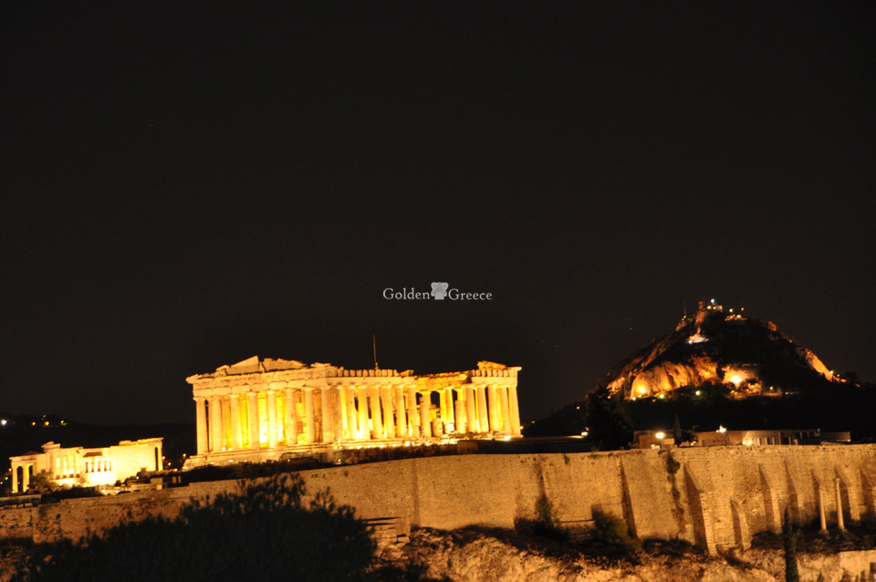
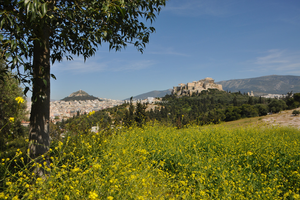
The ancient name of the city is Athens, (plural), because it originally comprised the set of settlements that were then united and developed into a city. The name has no etymology in Greek. The Greeks believed that the city was named after its patron, the goddess Athena, but it is equally possible that the goddess owes her name to the city.
Editor: Fotini Anastasopoulou
According to historical sources, Attica was first inhabited in the Neolithic era and was known as Akti or Akti. Kekropas, the first king of Attica, was the one who gathered the inhabitants who until then lived nomadically, and settled them in 12 settlements.
Western Attica was the cradle of ancient Greek civilization where Megara, Eleusis, Pages, Aigosthena, etc. flourished.
The center of Western Attica is Eleusis, which was one of the five holy cities of Ancient Greece. Its name indicates the coming of some important event. Its history dates back to 2000 BC. and is interwoven with the worship of the Goddess Demeter, protector of nature and grain vegetation.
It is the port of Vilia and a beautiful holiday resort that combines the pine-covered slopes of Kithairona with a nice beach. In the north-east of the settlement dominate the walls of the ancient Aigosthenes, which in ancient times were an important port and fortress in the Gulf of Corinth and the center of worship of the seer and healing hero Melampodas.
The fortress of Aigosthenes dates back to the 4th-3rd century BC. and is considered the best preserved ancient castle. Due to its border location, it belonged at times to the Megarians and the Athenians, while it was a member of the Achaean Commonwealth and for a short time of the Boeotian Commons.
Near the gate of the northern part, the foundations of a five-aisled basilica from the 5th century AD, with a mosaic floor, are preserved. In the Acropolis, a row of medieval monastery cells is preserved, in part, as well as a small church of the same era, which still functions today, dedicated to Agios Georgios.
Editor: Fotini Anastasopoulou
The area in ancient times was called Euripides, which means good wheat. During the 6th century BC in the wider area there were the small municipalities of Euripides, Kropias, Pilikas and Oias. Inscriptions, vases, grave sculptures and fragments of statues indicate the worship of Hercules in the area (Ano Limni, Zofria). Remains of historical monuments are the ancient wall "Dema" (4th century BC) 2.5 km west of Pyrgos on Pyrgathi hill, (4th-3rd century BC), the foundations of the house, (probably two-storey farmhouse of the 4th century BC west of its walls) and the Back Wall (early 4th century BC) outside the current construction site of the municipality.
Editor: Fotini Anastasopoulou
According to classical antiquity, in the area that is today the limits of the municipality, the traveler Pausanias mentions the existence of the municipality of Thria, Kopokidi, Hippotomades and Oia, the area of Reita (two lakes dedicated to the goddess Demeter and her daughter Persephone ) and the palaces of the Krokonids.
The history of the city dates back to the middle of the 19th century. The place of origin of the first inhabitants was the area of Koundouri and Hassia. In 1960 the inhabitants of Aspropyrgos numbered around 2,000, their main occupations were agriculture and animal husbandry and they supplied Athens with horticultural, cereal and dairy products.
Editor: Fotini Anastasopoulou
The history of the Vilia is directly linked to the legend of the capture of the inhabitants of Paleochori by pirates, who transported them and sold them to Italy. Today only the ruins and the small church of Agios Georgios are preserved from Paleochori. Those inhabitants who were saved from the rapture left Paleochori and created around 1230 AD. the current village of Vilia. During the years of the Turkish rule, Villas was the center of the region of the great Derveni (region of Megaridos) and seat of Turk Pasha. In the revolution of 1821, the Viliotes (together with the inhabitants of Kountoura and Mazios) were the first to offer their help in the sieges of Corinth, Thebes, Chalkida, Livadia and the Acropolis of Athens.
Editor: Fotini Anastasopoulou
Eleusis was one of the five holy cities of Ancient Greece. Its name indicates the coming of some important event. Its history dates back to 2,000 BC. and is intertwined with the worship of the goddess Demeter, protector of nature and the growth of grains. The oldest temple for the worship of the goddess Demeter seems to have survived until 1,000 BC. after the descent of the Dorians, a new geometrical temple was created, but the sanctuary remained in the same position. After the imposition of the Athenians on the Eleusinians (650-600 BC), instead of the small geometric sanctuary, a larger one was built, the worship of the goddess Demeter acquired a pan-Hellenic character, the city and the sanctuary were surrounded by strong walls and towers.
The Roman emperors favored the sanctuary and the city by building important works such as the Small Propylaia (54 BC), the Hadrian aqueduct, the bridge at the intersection of the Sacred Way, etc. With the imposition of Christianity, the Eleusinian Mysteries fell out of favor. In 392 AD the emperor of Byzantium Theodosios II expressly forbade their performance and in 395 AD. the temple was given over to the fire by Alaric's Ostrogoth raids.
For a long period that followed, the city of Elefsina remained in obscurity during the Ottoman period it was almost uninhabited and shortly before the foundation of the Greek state it was mentioned as a small fishing village.
Editor: Fotini Anastasopoulou
The first historical reference to Erythres is made by Homer. In recent history, the city was named Kriekouki in 1928, when it was renamed Erythres.
Editor: Fotini Anastasopoulou
The first settlement in Magoula was probably created as a winter stockade by Kountourio shepherds from Paleochori. As a village, Magoula began to develop after the Orlovic period, when the local population moved to more northern mountains to escape the revenge of the Turks.
In 1836, Magoula is mentioned as a village of the municipality of Elefsina and in the first official data of the Ministry of the Interior (1875) it is recorded as an 'agricultural village' with a population of 115 inhabitants. Magoula became an independent community in 1914 with the main occupations of its inhabitants being agriculture, animal husbandry, resin collection and beekeeping.
According to classical antiquity, in the area that is today the limits of the municipality, the traveler Pausanias mentions the existence of the municipality of Thria, Kopokidi, Hippotomades and Oia, the area of Reita (two lakes dedicated to the goddess Demeter and her daughter Persephone ) and the palaces of the Krokonides. The history of the city dates back to the middle of the 19th century. The place of origin of the first inhabitants was the area of Koundouri and Hassia. In 1960 the inhabitants of Aspropyrgos numbered around 2,000, their main occupations were agriculture and animal husbandry and they supplied Athens with horticultural, cereal and dairy products.
Editor: Fotini Anastasopoulou
The ancient city of Eleftherai is mentioned by the traveler Pausanias on the borders of the area of today's municipality, the ruins of which are preserved to this day. In 1815 the French poet Pouqueville writes about 'Mandra, the village of Kithairona', in his work 'Journey to Greece'. The home of the inhabitants of Mandra was Koundoura, which played an important role in the national liberation struggles, was burned three times by the Turks and produced heroes such as the commander of the 21st Zervonikolas and Evangelos Koropoulis who fought for a number of years alongside Pavlos Melas.
Editor: Fotini Anastasopoulou
Megara was one of the most important cities of Greek antiquity. Their original name was Nysa after its king, but it was renamed Megara as a mark of honor to the hero Megareus. Megara was inhabited during the Mycenaean era, but the descent of the Dorians around 1100 BC. marked their historical development. The key position of the city on the roads from Northern Greece to the Peloponnese and the ports of Nissaia on the Saronic and of Pago on the Corinthian helped the development of the Megara into a naval and mercantile power of the time with colonies in Sicily (Yvlaia Megara 728 BC. ), in Kyzikos (Propontida 680 BC) and Bosporus (Chalkidona 685 BC, Byzantium 660 BC)
Author: Fotini Anastasopoulou
The ancient writers, the newer travelers and the archaeological researches, place the ancient municipality of Anargyruntos, of the Erechtheid tribe, after the ancient municipality of the Aixonides Alos, on the borders of the current municipality of Vari.
The name of the ancient municipality is due to the foul-smelling plant anagiros - today's phlomos - while the modern one is attributed to the Arvanite root varr, which means grave-tomb. Perhaps the Arvanitic tribes gave this name, observing the imposing burial enclosures. The excavation revealed many tombs and burials in organized cemeteries, which further strengthen the name.
Remains of ancient settlements, farmhouses, roads, reservoirs, wells, numerous tombs, retaining walls, property conditions, burial enclosures, public open space, pipelines, ancient quarries etc. have been found. which absolutely verify the representation of Anagyroudos in the Parliament of five hundred with six deputies.
Life in Vari dates back to the 3rd millennium BC. Facilities and activities have been identified and excavated in the hills, in sites of the Kamini site and elsewhere dating back to the 3rd millennium.
The collection of obsidian blades, a volcanic rock from Milos, testifies to communication with the island of the Cyclades and trade relations.
The collection of ceramic material, hooks and weights together with sea shells, indicates the occupations of the inhabitants of the Proto-Hellenic era as well as their eating habits.
The excavations at the site of Kamini revealed organized cemeteries of Mycenaean times with many interesting findings.
The types of tombs - chambered and pit - and their offerings give information about the economic level of the inhabitants and provide demographic data.
The excavations brought to light part of the Mycenaean settlement with evidence of daily human activity (Thassos street). Therefore, a Mycenaean civilization is established in the area, extremely important for the enrichment of cultural information and knowledge.
In Geometric years life goes on without interruption. Installations and burials on the hill of Lathuriza as well as recent excavations reveal the image of the municipality in the Geometric period. The recent survey of a cemetery on a plot of land on Terpsichoris Street indicates the existence of a settlement dating back to the Geometric period.
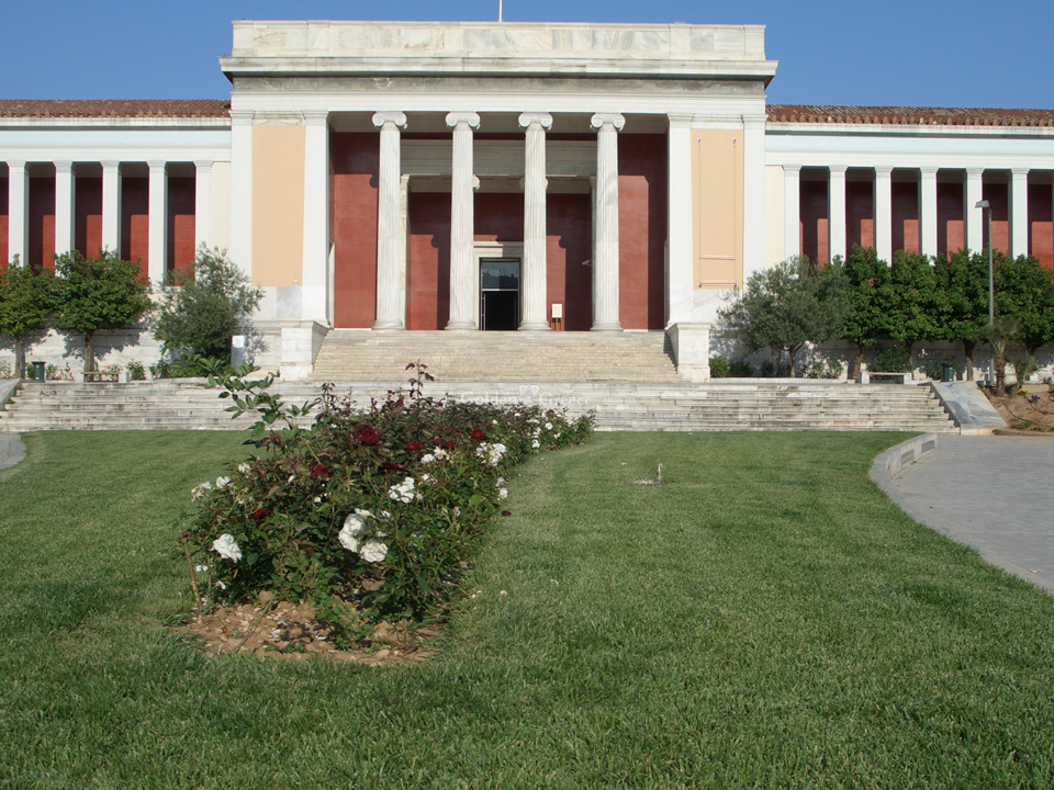
At the site "Cheroma" the extremely important cemetery of the 7th BC. century, of the Prosolonian period, with the great vessels of Anagyrontos, exhibited in the National Archaeological Museum, testifies to the uninterrupted continuity of the habitation and the standard of living.
The center of the ancient municipality was occupied by the hill Lathuriza and Lathouressa to the west of the current city. The earliest excavations on the hill revealed extensive residential remains, a sanctuary and a number of mobile finds dating from the 7th to the 4th BC. century.
It is a representative example of a settlement built during the archaic and later times. In a recent surface survey of the hill of Lathuriza, settlements were identified, whose arrangement is perimeter and which date back to the 5th and 4th BC. century.
The archaeological spade has revealed, in salvage excavations of the plots of the modern municipality, important and valuable elements for the form and way of life of the Anagyrasians.
The daily life of the Anagyrasians does not seem to have any substantial differences from that of the modern Variotes until now.
In the center are the flat cultivated lands, on the surrounding hills the houses, the reservoirs and all kinds of facilities.
The location of the land of Attica, where the ancient Anagyros and the modern Vari spread, is one of the most beautiful.
Between the blue of the Saronic and the gray-green of the ends of the Hymettos lies the area of habitation and cultural activity. The protection of the fertile valley by the ring-shaped hills (Dilofo, Lathuriza, Barako, Melissi, Pefkoto) imposed the ancient construction and communication, the choice places for the burial of the dead, the places of worship and the activities of the Anagyrasians in absolute harmony in the relationship man - environment.
These environmental conditions ensured the continuity and uninterruptedness of the human presence and activity that found its "voice" in the classical years in the area of the Anagyrounda market, which was revealed on Papafoti Street a few years ago.
A walled space, where the "exhibitions" and sales of the products took place, the exercises of the young Anagyrasians, the oppositions and osmosis about the political acts and decisions of the citizens, the choices of the six deputies for the Parliament of five hundred in the closed Asti.
Anagyrous, Cleisthenios Attic Municipality, had a representation in the Parliament corresponding to about 300 free citizens.
Text: Maria Kasimi - Soutou
The history of Oropos during antiquity can be sketched based on the passages of ancient authors and more directly with the inscriptions of Amfiaraos, which, due to its importance, was a point of reference for the wider area until the late period. However, superficial archaeological investigations have revealed findings indicative of the region's habitation since the prehistoric period. However, the investigations so far have been limited in scope and have not, at least not yet, focused on the period in question.
The first secure historical mention of Orops is in Herodotus. Others follow in Pausanias, Thucydides, Aristotle and Strabo. The last three identify Oropos with the Homeric Graia (Ill. B. 498). The ancient Oropos (municipality of Grais), in the place where the Skala Oropos is today, was probably the base of the colony of the Graians, who settled in Kymi of Campania. The hypothesis that the first Greeks with whom the indigenous inhabitants of Italy came into contact were the Grai, from whom the national name Gr eci by which the Greeks are now known in the West was derived, has been strengthened by the results of recent archaeological excavations in Staircase of Oropou. Oropos (Graia) participated in the colonization of Kymi along with Eretria and Chalkida with the primary purpose of finding metals.
The geographical position of Oropos on the borders of Attica and Boeotia and opposite Euboia, which was the granary of Athens, made it a disputed object of claim by the Eretrians, the Boeotians and of course the Athenians. Subsequently, Oropos enjoyed rare and short-lived periods of autonomy.
Editor: Fotini Anastasopoulou
In ancient times, the bay of Psatha served as a port and was called Panormos. It can combine bathing, eating and resting.
Editor: Fotini Anastasopoulou
MUNICIPALITY OF FILIS
At a very short distance from Athens, in the N.W. on the slopes of Mount Parnitha lies the historical municipality of Phyli. Whoever visits this place for the first time has the feeling that he is miles away from the bustling city.
And indeed the Tribe surrounded by the mountains and visually isolated from the huge metropolis gives the visitor the impression that he is in some distant village, on top of a high and beautiful mountain. The quietness and the idyllic landscape relax the senses. The heart and mind are soothed and calmed by the sound of birds, the reflection of the green landscape that crowns the Tribe from the northeast and the fresh air that floods the senses with forgotten scents of nature.
Fyli is one of the oldest municipalities of Attica. A witness to the history of the place stands the well-preserved ancient fortress located in the N.W. of Parnitha at an altitude of 850 m and at a distance of about 11 kilometers from the current city. The fortress was built at the end of the 5th century BC in a particularly strategic position, in the natural passage that in ancient times was the road that connected Boeotia with Attica.
An important place of religious importance during antiquity was the cave of Panos, consisting of two rooms intended for the worship of God Pan, protector of shepherds and flocks.
This cave is located in an inaccessible but impressive place above the Goura gorge at an altitude of 620 meters. In order to get down to its entrance, a stone slab has to be demolished which has slots made since antiquity.
Editor: Fotini Anastasopoulou