HIKING ROUTES
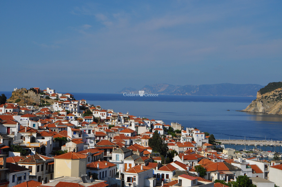
In addition to the beautiful beaches with crystal clear waters, the island of Skopelos is famous for its wonderful nature. For those interested in exploring the surrounding area, we recommend some great hiking trails.
Skopelos - Stafylos - Valanio Beach (old road)
Duration: 1 hour and 10 minutes
Distance: 5km.
Starting from the town of Skopelos, you walk about 700 meters up the main paved road towards Stafylos. Before reaching Tarsanas, turn left walking along a small dirt road. Crossing an area with olive groves, you reach a crossroads. You continue right and in a few minutes you come to a new intersection, where you go right and immediately left. From here on the road is straight. On your left you will find the chapel of Osias Irini of Chrysovalanto and after a ten minute walk, the picturesque church of Agios Panteleimon. In the area there are tree hollies and old maples along with several cypresses. Continuing the road from the chapel of Ag. Panteleimona and after passing some tall pine trees, you reach the intersection with the main asphalt road. From here you descend towards the beach of Stafylos. You cross the beach and reach the cape, where there is an archaeological site with remains of buildings from the Mycenaean era. A small and steep path descends from the cape to Valanio beach. In Stafylos and Valanio, egrets and other seabirds nest, if you are lucky you may see them flying. The coastline of Palukio next to Valanio is one of the most important living areas for the endangered Mediterranean seal in the Northern Sporades. If you spot one, move away without disturbing them. nesting herring gulls and other seabirds, if you are lucky you may see them flying. The coastline of Palukio next to Valanio is one of the most important living areas for the endangered Mediterranean seal in the Northern Sporades. If you spot one, move away without disturbing them. nesting herring gulls and other seabirds, if you are lucky you may see them flying. The coastline of Palukio next to Valanio is one of the most important living areas for the endangered Mediterranean seal in the Northern Sporades. If you spot one, move away without disturbing them.
Glossa-Loutraki
Duration: 30 minutes
Distance: 2.5 km.
In the southern part of the settlement of Glossa, a cobbled cobblestone road, the island's old road, begins, which intersects with the asphalt road and continues to Loutraki. It intersects once again with the asphalt road and then descends to the northern part of the settlement of Loutraki.
Skopelos-Delphi
Duration: 1 hour
Distance: 3km.
Starting from the town of Skopelos follow the ring road and, after passing the junction for Glysteri, you will come across a junction with a dirt road on the left. Following the dirt road you reach Avgeri, the highest valley of Skopelos, with terraces and fruit trees (apple, plum, cherry). Scattered here are the ruins of huts. At the point where the road ends, on its right, the path to the top of Mount Delphi begins. Birds of prey nest there, you might even manage to spot one. After a 15-minute walk under the windswept pines, you reach the forest firehouse at the top of Delphi (681m altitude). A few meters north of the lookout there is a rocky ledge, worth climbing to enjoy the panoramic view to the west.
Rematia Keramoto
Duration: 1 hour
Distance: 4.3 km.
You will start from the bus stop at the entrance of Glossa village and going east on the road, you will come across a water fountain. From this point begins a path that descends along the Keramotos ravine crossing an aria forest, while along the path flows a small river and there are stands of large plane trees. The path ends at Keramotou beach. Predators are often seen in the area (little woodpeckers, grebes, hornbills, etc.). Near the beach there is a chance to see Mediterranean seals.