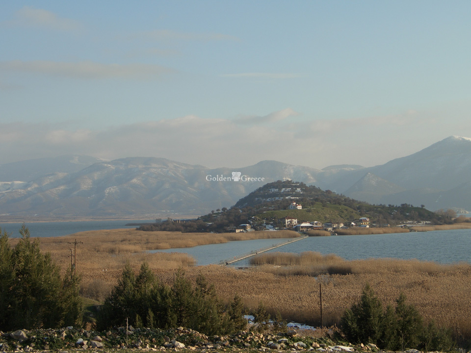
The Archaeological site of Petra is located in the north-eastern part of N. Florina, a short distance from Amyntaio on the western shore of Lake Petra.
The Hellenistic city of Petra was located in ancient times on the borders of the ancient district of Eordaia, on the border with Lygkistida, that is between Upper and Lower Macedonia. Built in a strategic position, on the slopes of a trapezoidal hill 720 m high, which dominates over the lake of Petra and the fertile plain. The city was probably founded in the middle of the 4th century. BC by Philip II in order to ensure the control of the northern and western borders of the Macedonian kingdom by uniting the local tribal groups.
Ancient remains of habitation have also been discovered in the area and based on the pottery found, they date back to the Late Bronze Age and the Early Iron Age (1200 - 600 BC). The next residential phase, with few remains, is placed in the second half of the 4th century. BC. Then during the early 3rd c. BC buildings were built on islets, while the main residential phase in the middle of the 2nd c. BC coincides with the peak of the city and is connected to the crossing of Egnatia Street near this area. The Egnatia road, built around 130 BC, passed a little south of the hill crossing the plain of Amyntaios, as evidenced by the six signposts (milestones) found in the area.
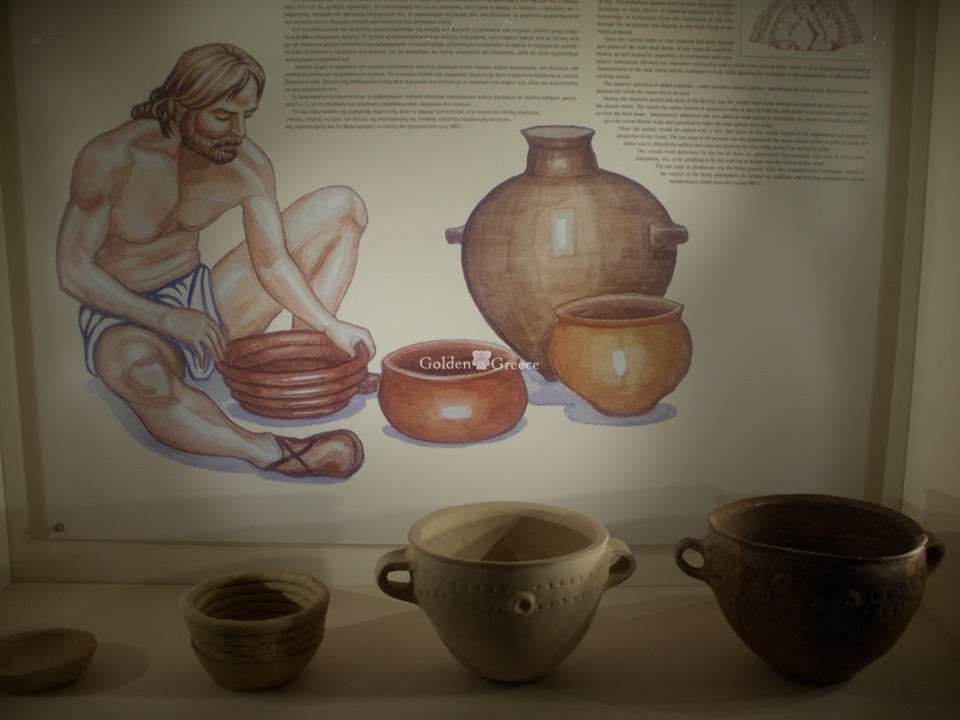
The settlement is a typical example of an Upper Macedonian county with an economy based on agriculture and animal husbandry, as evidenced by the finding of agricultural tools and facilities for processing grains and storing flour.
But during the heyday of the city, in the 2nd century BC, the simple agricultural economy changes as the settlement acquires an urban character, while it is distinguished by a high standard of living. Pottery, corroplastry and metalwork workshops operate in the city, as evidenced by sections of relief vase matrices and figurines found during the excavation research. Thus, with Egnatia in control of the region, it is now a notable commercial center that trades with many Greek cities, as can be seen from the coins that come from Pella, Thessaloniki, Amphipolis, Akarnania, Rhodes and Durres. However, administratively and economically the city depended on the capital of the Macedonian kingdom, Pella.
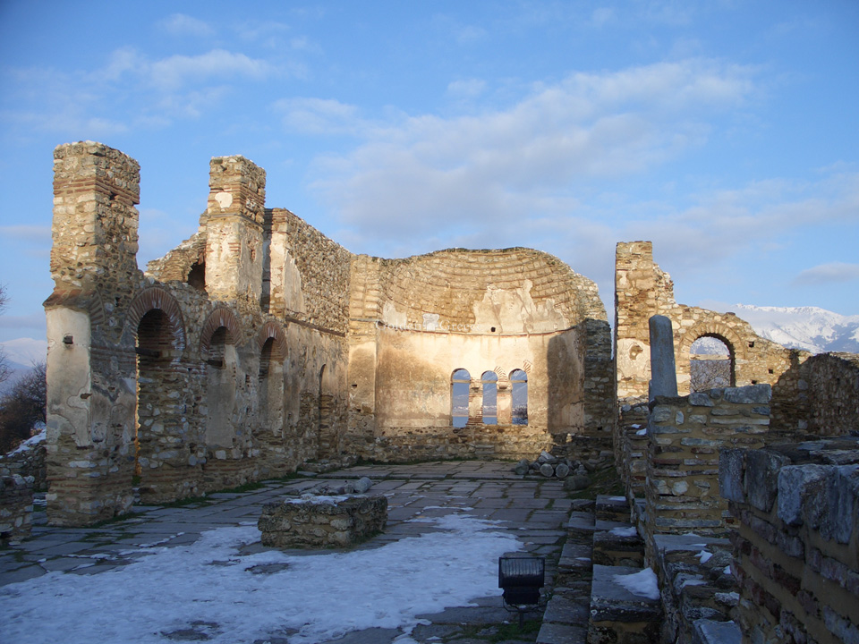
The excavation revealed a well-built strong wall, which enclosed a settlement with a free urban organization (not following the hippodamian system of other modern cities), which makes the best use of the curves of the hill on which it stands.
The residential areas are organized in groups of three with common external walls, while the houses are built in contact with each other. These are two-story constructions, without a yard, where the transition to the upper floor was made by a wooden or brick staircase. The houses had underground spaces that were used as warehouses and workshops. The ground floors of the houses are built with mud-brick construction, while the upper floors are made of lighter materials (wood, mud and straw).
On the upper floor of the houses were the daily living rooms of the family, the women's room and the man's room. The walls of these rooms were elaborately decorated with colored mortars, imitating orthomarbling, in early "Pompeian style", identical to those of Pella.
The houses of the Petras contribute to a better understanding of the Hellenistic residence. A system of roads criss-crossed the settlement, of which the main arteries paralleled the curves of the hill, while secondary, small, irregular lanes led to the houses.
At the same time, the excavation revealed the water supply clay pipes that lead to fountains and wells. Important buildings of the archaeological site are the sanctuary of Zeus - according to the inscription found inside it - with the altar as well as the large underground python found nearby.
It is probable that the place can be identified with the Kelli of the medieval travelers or even with Eordaia, seat of the Koinos of the Eordaeans, but still the research has not settled on a view that is generally accepted.
The settlement was destroyed and abandoned in the middle of the 1st century. BC era of Roman civil strife. During the excavation, the so-called destruction layer was identified, which certifies the period when the city was abandoned, while at the same time, a treasure of 125 silver dinars found in a residence and dated to the period 105 - 43/42 BC indicates the Roman presence.
The settlement, although its sporadic habitation was found up to the 6th c. AD it was moved to the site of the current village of Petra, where part of a cremation chamber and a Roman cemetery have been found.
Editor: Fotini Anastasopoulou